Skip to content
FREE SHIPPING FOR ORDERS ABOVE $200
Skip to product information
1 of 1

Ireland Map Poster (1690) - Vintage Kingdom of Ireland Wall Art

€39,95
€39,95 €48,95
Sale Sold out

Lowest price in 30 days: €39,95 EUR

Frame style: Unframed
Size: 91x61cm | 24x36in
  • Free Shipping - On All Orders Over $250!
Secure Payment
  • American Express
  • Apple Pay
  • Bancontact
  • BLIK
  • Google Pay
  • Maestro
  • Mastercard
  • Shop Pay
  • Union Pay
  • Visa

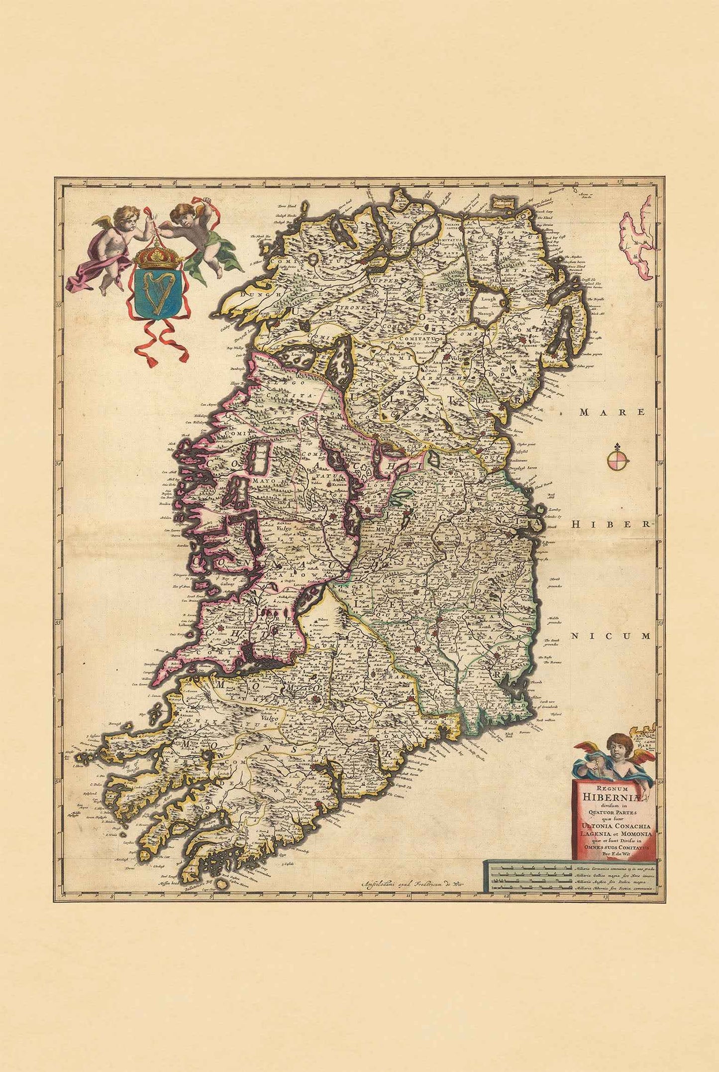
Discover the elegance of 17th-century cartography with this beautiful Ireland Map Poster titled “Regnum Hiberniae,” created by Frederick de Wit around 1690. Published as part of the renowned “Atlas Minor sive Geographia Compendiosa” by Nicolaes Visscher, this richly detailed historical map presents the Kingdom of Ireland in a classic Baroque cartographic style.

Expertly engraved and hand-colored in outline, the map depicts Ireland divided into its four historic provinces: Ultonia (Ulster), Conachia (Connacht), Lagenia (Leinster), and Momonia (Munster). The elegant hand coloring enhances the distinction between regions while preserving the refined aesthetic characteristic of late 17th-century Dutch atlas maps.

The composition is filled with intricate decorative details including an ornate title cartouche, heraldic symbols, cherubs, and the coat of arms of Ireland. Mountains, lakes, rivers, roads, ports, towns, and cities are illustrated with remarkable precision using pictorial relief techniques that add both geographic depth and artistic charm to the landscape.

Typical of the golden age of European cartography, this antique Ireland map beautifully combines scientific accuracy with decorative artistry. The detailed representation of infrastructure and settlements reflects the importance of trade, transportation, and regional identity during the period.

Perfect for collectors, travelers, historians, genealogists, and admirers of Irish heritage, this vintage Ireland poster makes an elegant wall decor piece for offices, libraries, studies, living rooms, and interiors inspired by history and classic European design.

This is a reproduction print of a historical map

Author:
Visscher, Nicolaes, 1649-1702.

Date:
1690

Source: David Rumsey Map Collection, David Rumsey Map Center, Stanford Libraries

We use a top quality Canon printer
Canon ImagePROGRAF PRO 2600 providing:

  • 2400 x 1200 dpi
  • 12-color printing system using Lucia-PRO II inks
  • High-precision printing with 5 pl droplet size per color
  • Print head with nozzle compensation function

The print is done on Cotton Canvas (
390 g/m²) prociding a vintage map feeling.

Currently we offer black hardboard frames with polystyrene plastic front protection.

Available in sizes:

  • 91x61cm | 24x36in
  • 70x50cm | 28x20in

We work with a range of trusted logistics providers to ensure you get the best balance of cost and delivery quality, including FedEx, UPS, and DPD. We currently ship to 30 countries worldwide, including 25 countries within the European Union, as well as the United Kingdom, Switzerland, Canada, Japan and the United States.

All orders include full tracking, so you can monitor your shipment every step of the way. We also offer free shipping on all orders with a cart value above $200.

If your postal code is not supported by our standard shipping options, please contact us at contact@strategymaps.co
and we will arrange a custom shipping solution tailored to your location.

We have a 30-day return policy, which means you have 30 days after receiving your item to request a return. To be eligible for a return, your item must be in the same condition that you received it, and in its original packaging. You’ll also need the receipt or proof of purchase.

When buying within the European Union have the right to cancel or return your order within 14 days, for any reason and without a justification.

Read more about return policy here.

View Product Details

From map lovers for map lovers

Get Your Hometown Blueprint Map - Modern City Street Wall Art