


Authors: A.J. Johnson & Dr. Charles Müller
Years: 1870–1874
This is a reproduction print of three historical maps of the Roman Empire and Ancient Rome, originally published between 1870 and 1874. Together, they form a collection illustrating the Roman world across different periods and scales — from the vast empire to the heart of Rome itself.
The collection includes:
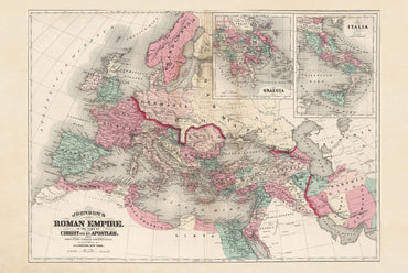
Roman Empire in the Time of Christ – 1870
By A.J. Johnson. A historical reconstruction of the Roman Empire around the time of Christ and the Apostles, also showing St. Paul’s journeys. It presents Roman territories across Europe, North Africa and the Middle East, together with major cities, provinces and frontiers.
Roman Empire After the Division – 1873
By Dr. Charles Müller and engraved by Edward Weller. The map depicts the Roman Empire following its division into Eastern and Western Empires, with Rome, Constantinople and Alexandria prominently marked. An inset of the Parthian Empire provides additional context for Rome’s eastern frontier.
Rome in the Time of the Emperors – 1874
By Dr. Charles Müller and engraved by Edward Weller. A detailed reconstruction of Ancient Rome, featuring the Colosseum, Roman Forum, Imperial Fora, roads, monuments and surrounding terrain, accompanied by additional inset plans of the ancient city.
Together, these three maps create a comprehensive visual journey through the Roman Empire, its division, and its imperial capital.